Carbon Flux Measurements Super Site
Savannah River National Laboratory
Carbon Flux Measurements Super Site
The Savannah River National Laboratory (SRNL) Carbon Flux Super Site provides a unique resource for intensive study of the carbon exchange (flux) for forested ecosystems characteristic of the southeast U.S.
Through this DOE Office of Science-funded project, researchers gather information from the Carbon Flux Super Site to investigate carbon flux on regional and local levels.
Southeastern pine forests are very effective at sequestering anthropgenic emissions of CO2. In some years, these forests uptake more than the entire inventory of U.S. CO2 emissions. However, the exchange of carbon between the free atmosphere and terrestial ecosystems is not fully understood, particularly at local scales. Better understanding of these processes through targeted research will lead to better global climate models and improved climate change forecasts.

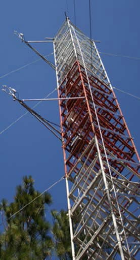
SRNL Forest Flux Tower
SRNL Fast Facts
- National Laboratory for DOE Office of Environmental Management
- Supporting customers at SRS, DOE and other federal agencies nationally and internationally
- Applied research, development and deployment of practical, high-value and cost-effective technology solutions in the areas of national security, clean energy and environmental stewardship
- Operated and managed by Battelle Savannah River Alliance
Super Site Resources
The Carbon Flux Super Site is designed to provide measurements for CO, CO2, water vapor, and meteorological variables that can be used to characterize carbon flux over a wide range of spatial scales that few other research facilities can match. Specific resources include:
- The SRNL Forest Flux Tower: Special sensing equipment collects detailed multi-level measurements necessary to determine carbon and water vapor fluxes within the forest. This tower also gathers soil moisture measurements as part of the COSMOS network (University of Arizona), and foliage morphology using the PhenoCam technology (Harvard University). Routine observations collected at the Forest Flux Tower are forwarded to the Carbon Dioxide Information Analysis Center (CDIAC) at the Oak Ridge National Laboratory.
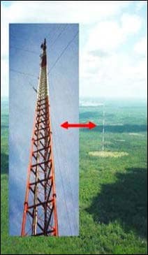
- South Carolina Tall Tower: Carbon, water vapor, and meteorological measurements, as well as sampling for approximately 50 trace greenhouse gases, are taken at multiple levels on the 1,500 foot tall tower. This data, which is collected as part of NOAA’s international Carbon Tracker program, provides the key link between regional and local scale processes.
- Leveraged Measurement Systems: SRNL’s Atmospheric Technologies Group conducts an extensive meteorological monitoring program for operations at the Savannah River Site. Measurements are taken from a network of standard meteorological towers, supplemented by vertical profiles of the atmospheric boundary layer from optical remote sensing (lidar) and sound wave detection (sodar) systems.
Special Studies in a Managed Environment
The Carbon Flux Measurement Super Site leverages the availability of a large, managed ecosystem at SRS and provides a unique opportunity for the international community to conduct research on terrestrial carbon exchange within a critical ecosystem.
In particular, understanding vertical transport of CO2 at night is vital to distinguishing local- to regional-scale and continental-scale transport in global carbon budgets.
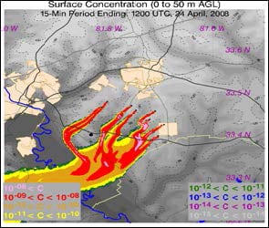
SRNL investigated this issue through a field study in which tracer gas was released from 12 locations upwind of the Tall Tower. Meteorological and tracer gas concentration data were collected from Tall Tower measurements and numerous other portable samplers placed in the plume path. A high-resolution numerical simulation was then executed to provide a three dimensional estimate of plume behavior. Model results were compared to the observed tracer gas data. Ongoing evaluations of model performance against these data will be used to improve model capabilities as a predictive tool for simulating terrestrial CO2 budgets.

The Carbon Flux Measurement Super Site provides data representing regional to local spatial scales.

Numerical model simulations of trace gas release upwind of the Tall Tower.
Partners in Success
DOE Office of Science, Biological and Environmental Research Divisions (SC-23)
The University of Georgia
National Oceanic and Atmospheric Administration, Global Monitoring Division
USDA Forest Service-Savannah River
Oak Ridge National Laboratory
Brookhaven National Laboratory
Download Fact Sheet
Contact Information
Steve Chiswell
803.725.9488
steven.chiswell@srnl.doe.gov